Cartersville Georgia Chapter
#1593 Cartersville Georgia
#1593 Cartersville Georgia
15 RIDES FOR '26
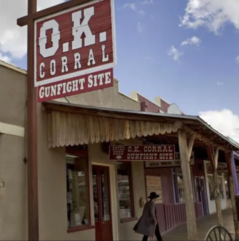
1 TOMBSTONE, AZ
O.K. CORRAL
CHECK IN LOCATION : "O.K. Corral Gunfight Site" 326 E. Allen St., Tombstone, AZ 85638 (Note: Vehicles are not permitted on Allen St. but free parking in municipal lots are nearby) One of the most infamous shootouts of the Wild West took place in Tombstone, Arizona on October 26, 1881. On that chilly afternoon, a simmering dispute between the cattle-rustling Clanton-McLaury gang and the three Earp brothers and their friend Doc Holliday erupted into a wild gunfight behind the O.K. Corral Within 30 seconds, close to 30 shots were fired, all at close range. When the smoke cleared, three of the five members of the Clanton-McLaury gang were dead, and two of the Earp brothers and Doc Holliday had been shot but were still alive. The Gunfight at O.K. Corral has become an enduring symbol of the lawlessness of the old West, and today, tourist flock to Tombstone for reenactments of the famous gun battle.
|
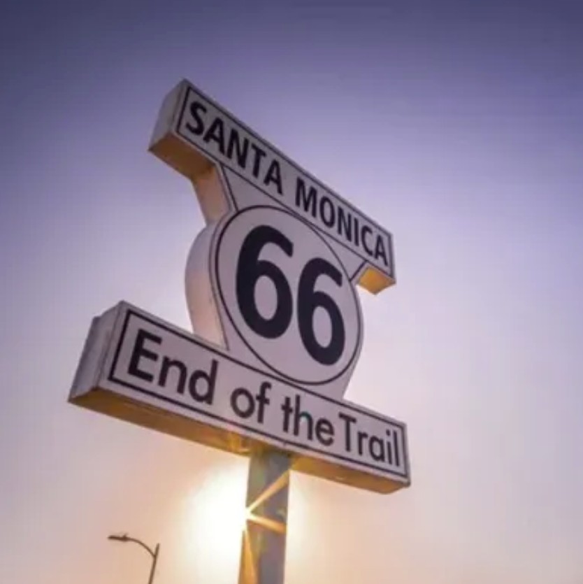
2 SANTA MONICA, CA
ROUTE 66 - END OF THE TRAIL
CHECK IN LOCATION: "End of the Trail" at the Santa Monica Pier. Approximate address: 322 Santa Monica Pier, Santa Monica, CA 90401. The sign is located near the pier's western end, just past Bubba Gump Shrimp Co. (Note: you will need to park and walk to the location. Paid parking nearby) Few American icons conjure nastalgia for the golden age of motoring like Route 66. Celebrated in film, television, and literature as the "Mother Road" and "America's Main Street," the 2400-mile highway stretches across two-thirds of the country through eight Midwestern and Western states. The Road carried generations westward from Chicago to California - some seeking fame and fortune in the Golden State, others fleeing poverty during the Dust Bowl of the 1930s, and countless families road-tripping in station wagons, stopping for kitschy souvenirs at roadside attractions. U.S. Highway 66 was established in 1926 by the Bureau of Public Roads as a part of the Federal Highway System and was decommissioned in 1985. Although portions have long been absorbed by interstate highways, Route 66 has enjoyed a renaissance and remains a bucket-list road trip for drivers and motorcyclists. |
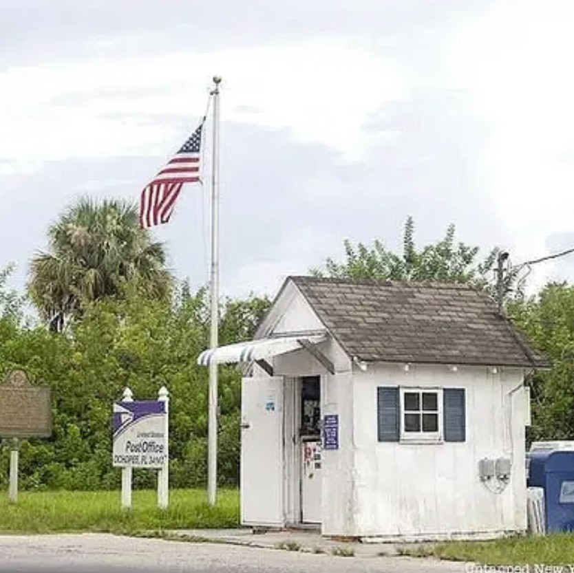
3 OCHOPEE, FL
NATION'S SMALLEST POST OFFICE
CHECK IN LOCATION: Ochopee Post office, 38000 Tamiami Trail East, Ochopee, FL 34141 Amongst the alligators and snakes in the Florida Everglades, you might be suprised to find a U.S. Post Office. In fact, the Ochopee Post Office is recognized as the smallest on in the U.S. At only 61 square feet, the building was originally an irragation pipe shed, and was pressed into service in 1953 when the original post office/general store was destroyed in a fire. In operation continuously since then, it serves customers in a three-county area and attracts visitors seeking a coveted Ochopee Postmark.
|
||
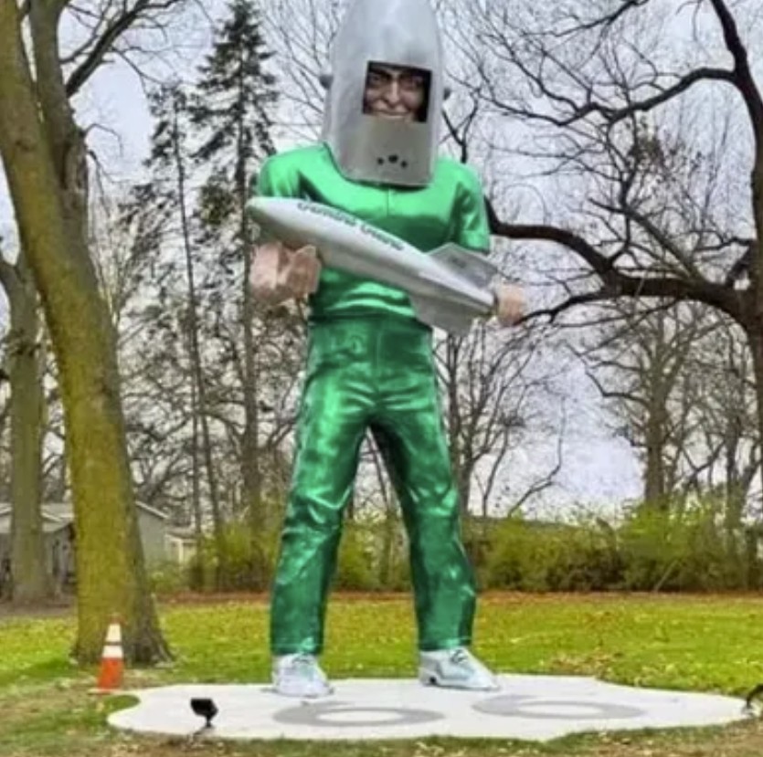
4 WILMINGTON, IL
GEMINI GIANT
CHECK IN LOCATION: Gemini Giante Statue, 201 Bridge St. Wilmington, IL 60481 The Gemini Giant is truly a giant among giants, one of many iconic roadside attractions along Route 66. The 30-foot-tall "Muffler Man" statue, attired in a green space suit and silver helmet, cradles a rocket ship in its arms. The towering figure stood gaurd outside the Launching Pad Restaurant in Wilmington, IL from 1965 until it closed in 2024. Afterwards it was moved to Wilmington's South Island Park, where it is displayed today. These fiberglass behemoths were manufactured by the hundreds throughout the 1960s and early 70s, and were often placed outside muffler repair shops, hence the nickname "Muffler Men." If you're looking for souvenirs during your Gemini journey, the Landing Pad Gift Shop next door offers bobbleheads and all sorts of Gemini Giant and Route 66 merchandise (the shop is open noon to 6:00 pm Thursday through Monday, from April to November).
|
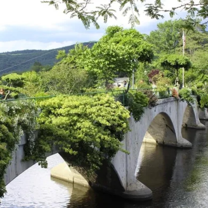
5 SHELBURNE FALLS, MA
BRIDGE OF FLOWERS
CHECK IN LOCATION: "Bridge of Flowers" sign, located near 12 Water St., Shelburne Falls, MA 01370 From eyesore to eye candy, the Bridge of Flowers was transformed almost 100 years ago from a derelict, weed-covered mess to a showcase of eye-catching plants and flowers. The grraceful arches of the concrete structure span the Deerfield River between the towns of Shelburne Falls and Buckland, MA. Constructed in 1908 for trolley cars, the bridge became obsolete in 1927 after the trolley company went out of business. Demolishing the bridge was deemed prohibitively expensive, so it was let to deteriorate in place. A local couple, however, had a different idea. They generated publicity for a renovation project, and community groups and volunteers pitched in, pulling weeds, bringing in topsoil and fertilizer, and planting seeds for flowers and plants. The footbridge is "in bloom" from April through October and is open to pedestrians. There is no fee, but donations are welcomed. More info at www.bridgeofflowersmass.org |
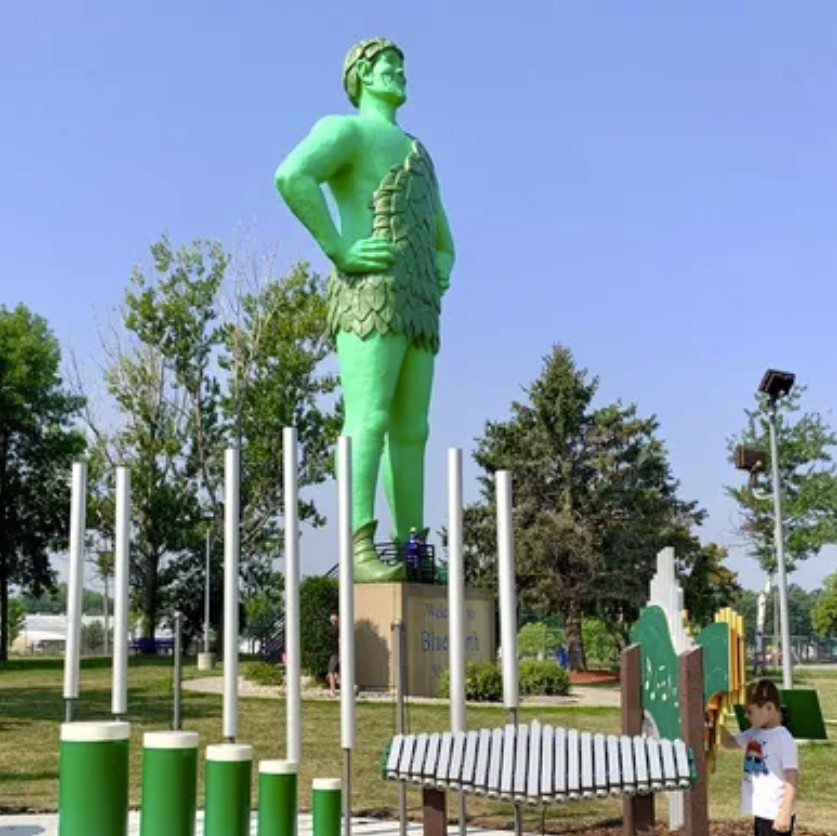
6 BLUE EARTH, MN
JOLLY GREEN GIANT STATUE
CHECK IN LOCATION: Jolly Green Giant Statue, 1134 Green Giant Lane, Blue Earth, MN 56013 Standing more than 55 feet tall and weighing 8000 pounds, the Jolly Green Giant statue in Blue Earth, MN, suggests you mother was right-eating your vegetables makes you big and strong. The statue was the brainchild of a local radio host hoping to draw more visiters to the sleepy town. He approached the Geen Giant company, then based in Le Sueur, MN and in 1978 received permission-but no funding-for the statue. The community rallied behind the idea, raised the money, and since 1979 the Giant has stood tall in a park off Interstate 90. Accross the parking lot, the Giant Welcome Center houses what's said to be the largest collection of Green Giant memorabilia in the world, along with visitor info and a gift shop.
|
||
|
|
||||
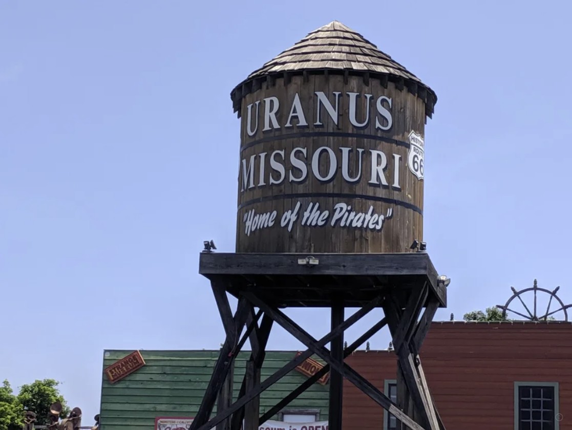
7 ST. ROBERTS, MO
URANUS, MO TOWN CENTER
CHECH IN LOCATION: Uranus Water Tower, 14400 State Highway Z, St. Roberts, MO 65584 Among all the roadside attractions and oddities along Route 66, Uranus, Missouri stands out for its unusual name. Not a real town, but a marketing gimmick sure to appeal to anyone with a 13-year-old's sense of humor, Uranus is actually part of the city of St. Robert, MO. The ersatz town, a collection of shops and activities with pun-filled names (Putt Pirates Mini Golf, anyone?), was dreamed up in 2015 by businessman Louie Keen, who calls himself the Mayor of Uranus. Understandably, the farcical town's maniker has raised a few disapproving eyebrowns, but the mayor is hoping you'll stop by to visit and help him make Uranus great again.
|
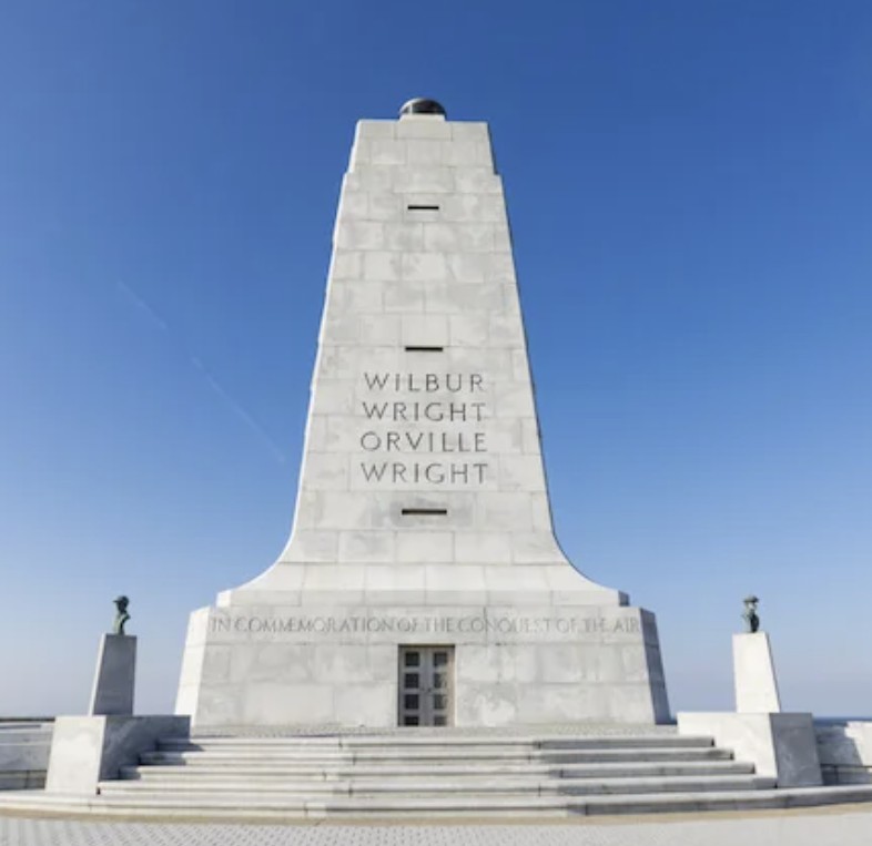
8 KILL DEVIL HILLS, NC
WRIGHT BROTHERS NATIONAL MEMORIAL
CHECK IN LOCATION: Wright Brothers Monument atop Big Kill Devil Hill, 1000 N. Croatan Highway, Kill Devil Hills, NC 27948 (Note: Entry fee applies, or National Parks and Federal Recreational Land passes are accepted). The morning of December 17, 1903 dawned cold and windy near Kitty Hawk, on the Outer Banks of North Carolina. There Wilbur and Orville Wright, self-taught engineers from Dayton, Ohio, planned to make history. At 10:35 am, their Wright Flyer airplane, with Orville at the controls, took off from the flat, sandy ground of Kill Devil Hills and remained airborne for 12 seconds, covering a distance of 120 feet. It was the first controlled, powered flight in history, firmly establishing the brothers a aviation pioneers. In 1927, Congress authorized the creation of Kill Devil Hill Monument National Memorial, and a 60-foot-tall Art Deco granite memorial was dedicated there in 1932. The site was rename Wright Brothers National Memorial in 1953. |
|
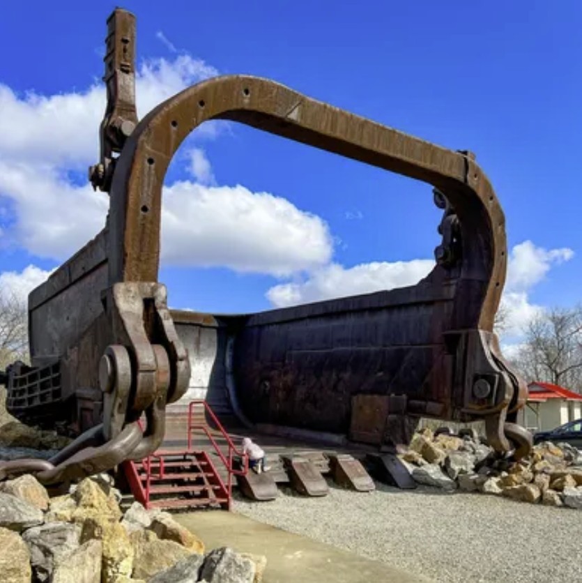
9 MCCONNELSVILLE, OH
BIG MUSKIE BUCKET
CHECK IN LOCATION: The Big Muskie Bucket in Miner's Memorial Park (in Jesse Owens State Park), 4470 OH-78, McConnelsville, OH 43756 The "Big Muskie" was a massive earth-moving machine used for coal mining. Its bucket alone weighed 230 tons and could hold 220 cubic yards of material weighing up to 325 tons (220 cubic yards is approximately the size of a dozen hippopotamuses, 12 Volkswagen Beetles, or a Million golf balls). Built in 1969 by the Bucyrus Erie Co., Big Muskie was the largest single-bucket dragline excavator in the world, almost 22 stories tall and weighing 27 million pounds. It was built for the Central Ohio Coal Company, where it ran 24 hours a day, 364 days a year. In 1991, with decreasing demand for high-sulfur coal and high operating costs, Big Muskie was shut down, dismantled, and sold for scrap. Only its massive bucket was preserved, and is now displayed at Miner's Memorial Park at Jesse Owens State Park in McConnelsville, OH.
|
|
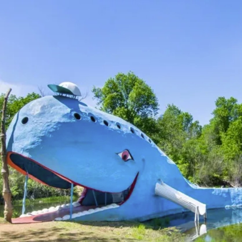
10 CATOOSA, OK
BLUE WHALE OF CATOOSA CHECK IN LOCATION: Blue Whale of Catoosa, 2600 OK-66, Catoosa, OK 74015 Built as an anniversay present for his wife and as a place fo his grandkids to play, the Blue Whale of Catoosa was completed in 1972 by zoologist Hugh S. Davis and is an iconic Route 66 landmark. Eighty feet long and twenty feet tall, Davis modeled the smiling concrete whale after real blue whales, the largest living mammals which can grow up to 100 feet in length and weight up to 200 tons. Now owned by the city of Catoosa, Oklahoma, the Blue Whale and its park are currently undergowing renovations and sprucing up for the 100th anniversay of Route 66. It is expected to reopen in late spring or early summer 2026; however, the whale remains visible and can be photographed from beside the highway.
|
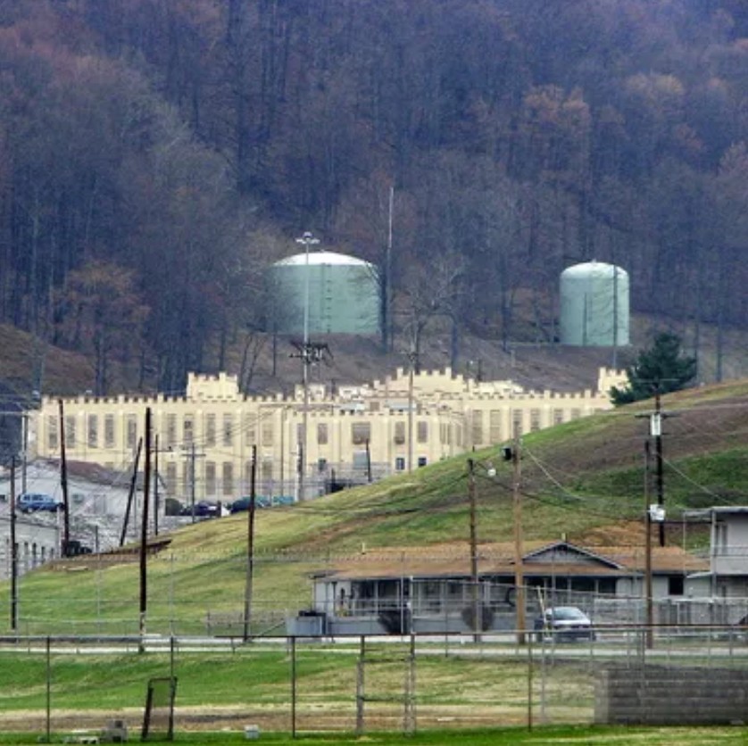
11 PETROS, TN
HISTORIC BRUSHY MOUNTAIN STATE PENITENTIARY
CHECK IN LOCATION: Brushy Mountain State Penitentiary sign outside the prison gate, 9182 TN-116, Petros, TN 37845 (there is no fee unless you enter prison grounds). Known as "The End of the Line," the Brushy Mountain State Penitentiary held some of Tennessee's worst Criminals. In operation from 1896 through 2009, the maximum-security prison housed murderers, rapists, kidnappers, and other ne'er-do-wells. One of its most infamous inmates waas James Earl Ray, the assassin of Dr. Martin Luther King, Jr. who tried to escape several times. Although the prison did not have a death row, many inmates died there, and the facility is said to be haunted. Today the historic penitentiary operates as a tourist attraction, offering guided and self-guided tours and night-time "Paranormal Investigation" tours (which are costly and must be booked in advance). There is a restaurant and micro-distillery onsite. |
12 AMARILLO, TX
CADILLAC RANCH
CHECK IN LOCATION: Cadillac Ranch, 13651 Interstate-40 Frontage Rd., Amarillo, TX 79124 A monument to the golden age of automotive tail fins, Cadillac Ranch is perhaps one of Route 66's most well known attractions. Ten vintage Cadillacs, manufactured between 1949 and 1963 are buried in a straight line at a 60-degree angle, nose-down, tail-up, in an Amarillo field. The installation was created in 1974 by a group called Ant Farm, an art collective based in San Francisco. An eccentric local millionaire provided the inspiration, land, and funding for the project. Its graffiti-covered automobilies are a constantly-changing riot of colors, thanks to the hordes of visitors who bring spray paint to add their own artistry to the exhibit. Rather than being considered an act of vandalism, spray-painting the vintage Caddies is encouraged, but visitors are requested to spray only the cars - not the surrounding property - and to properly dispose of empty spray cans.
|
||
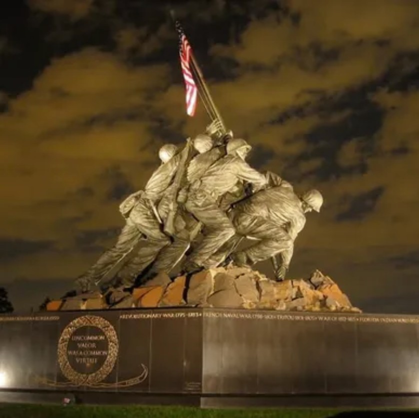
13 ARLINGTON, VA
IWO JIMA MARINE MEMORIAL
CHECK IN LOCATION: Iwo Jima Marine Memorial Statue. The statue is located in a park immediately outside Arlington National Cemetery; search for "Marine Corps War Memorial" in H-D Ride Planner, or use this nearby address: 1400 N. Meade St., Arlington, VA 22209. The Marine Corps War Memorial - also known as the Iwo Jima Marine Memorial - was dedicated by President Dwight D. Eisenhower on November 10, 1954, the 179th anniversary of the U.S. Marine Corps. Based on an iconic Pulitzer Prize-winning photograph by photojornalist Joe Rosenthal, the cast bronze sculpture depicts six Marines raising the American flag atop the summit of Mt. Suribachi during the World War II Battle of Iwo Jima. The memorial's inspription reads, "In Honor and Memory of the Men of the United States Marine Corps Who Have Given Their Lives to Their Country Since 10 November 1775." In addition to memorializing the Marines who have lost their lives, the memorial is also dedicated to "Their Comrades of Other Services Who Fell Fighting Besides Them."
|
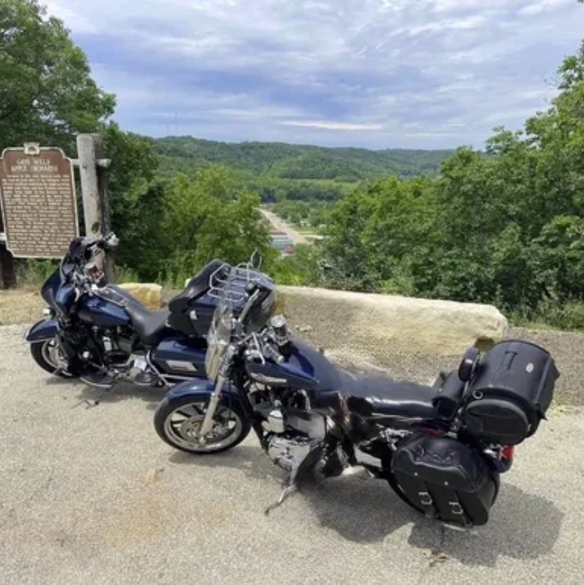
14 GAY MILLS, WI
WISCONSIN'S DRAGON
CHECK IN LOCATION: Historical Marker for Gays Mills Apple Orchards at scenic overlook on WI-171, approximately half a mile east of the intersection with WI-131 as you travel east on WI-171 (see Ride Planner route for approximate location) Sometimes the best motorcycle rides are hidden gems, known only to those locals privy to the secret. "Wisconsin's Dragon" is one such ride. A Google search for it turns up nary a mention. But thanks to a recommendation from Ron Paulick, Jr. and his wife Trish, H.O.G. members from Fond du Lac, Wisconsin, the route is no longer a mystery. Named after the popular Dragon in the Great Smoky Mountains, this figure-8 loops through south-central Wisconsin, has lots of twists and turns, and scenic overlooks. Says Ron, "Most of the route is two lanes; at the top of the hill at the Gays Mills Apple Orchards there is an overlook with great views and a historical marker". He adds the route was given its name by local riders, but until now has remained virtually unknown to outsiders. "Its not well known, even in Wisconsin because it's a narrow road that's not traveled much," Now that the secret's out, let's ride! |
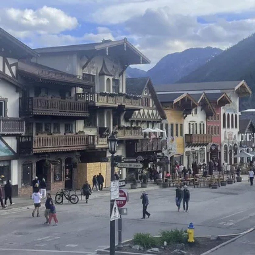
15 LEAVENWORTH, WA
CHECK IN LOCATION: Wooden carved nutcracker Statue, 707 U.S. Highway 2, Leaventworth, WA 98826 (the statue is located in front of "A Book For All Seasons" bookstore, which is actually on Front St., parallel to U.S. 2). Nestled in the foothills of Washington's Cascade Mountains, the town of Leavenworth is proof you don't have to travel to Europe to visit a Bavarian village. Complete with old world architecture, beer gardens, bratwurst, and bands playing oom-pah music, you'll feel like you've been transported across the pond. Leavenworth was origonally named Icicle Flats in the 1880s. The name later changed to honor Capt. Charles Leavenworth, an early settler who mapped the village. It was a boomtown throughout the early 20th century thanks to its lumber industry and rail transportation, but its fortunes declined after logging decreased and the rail lines were re-routed. In the early 1960s, town fathers developed plans to capitalize on its alpine ambiance and remade Leavenworth as a Bavarian moutain village, and the town now acttracts some 2.5 million visiters each year.
|

Regular meetings
Meetings are open to guests, held the 4th Saturday of the month, upstairs in the HOG Pen @ 10:00 AM
Please check the calendar for updates and changes.
![]()
![]()
Copyright © 2026 - Cartersville Georgia Chapter of Harley Owners Group #1593
Privacy Policy